Interactive maps: 6 Eastern Kentucky counties among highest hidden flood risk in U.S.
READ MORE
Waiting for the creeks to rise
As flooding becomes more frequent, vulnerable Eastern Kentucky communities wrestle with how much damage they can take
Expand All
Eastern Kentucky is among the most vulnerable land-locked terrain when it comes to flooding from rainfall. The Federal Emergency Management Agency’s maps do not adequately capture flood risk from rainfall, meaning hundreds of thousands more people may be vulnerable to flooding and not know it.
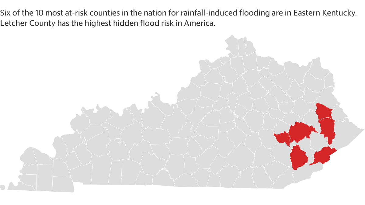
Six of the top 10 counties in America with the highest hidden flood risk are in Eastern Kentucky, according to data from the First Street Foundation, a nonprofit flood research and communications group that charts property-level flood risks. Hidden flood risk is the discrepancy between how much flooding FEMA claims happens versus how much flooding actually happens.
Letcher County has the highest hidden flood risk in the nation, outranking New Orleans. FEMA maps for Letcher County show 1,456 houses are at risk of flooding. First Street’s more exhaustive property-level maps show that number is significantly higher: 7,358, a 47% difference.
Hazard has the largest proportion of properties at risk (32%), and Farley in McCracken County has the greatest relative growing risk. Six percent of the town’s properties faced a substantial flooding risk in 2020; over the next 30 years, that percentage is projected to jump by 261%.
Explore flooding risk in the U.S. and Eastern Kentucky on these two interactive maps, with data from American Inequality.
This story was originally published January 23, 2022 at 5:00 AM with the headline "Interactive maps: 6 Eastern Kentucky counties among highest hidden flood risk in U.S.."