‘Swept away time after time.’ Floods are more frequent, and E. KY. residents pay the price.
READ MORE
Waiting for the creeks to rise
As flooding becomes more frequent, vulnerable Eastern Kentucky communities wrestle with how much damage they can take
Expand All
By the time Leranda Hayton noticed her yard in Smith Bottom Loop was flooding, water was already lapping onto the third step leading up to her trailer.
It was close to 7:30 a.m. on New Year’s Day. Hayton, peering out her window in the dark with a flashlight that reflected off the still-rising water, had been woken by her German Shepherd Luna’s barks; the dog was alarmed by the water rushing into her pen.
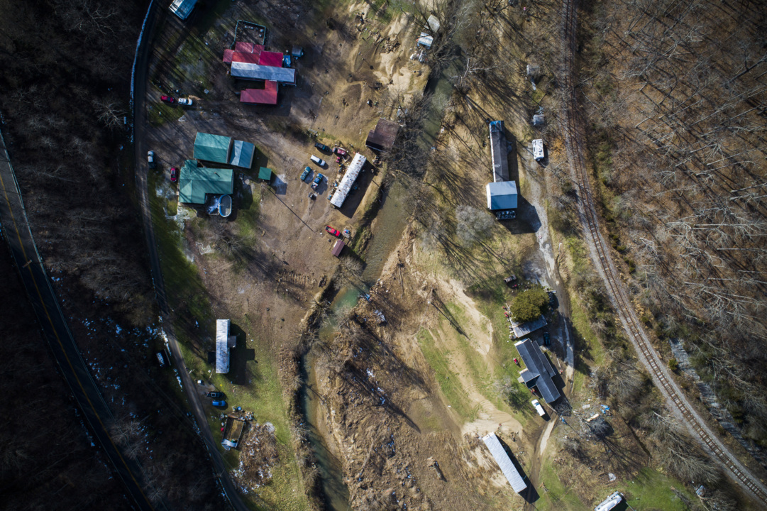
Like most Eastern Kentucky communities, Sidney, an unincorporated town in Pike County, sits in a valley at the base of steep and compact surrounding hills. The whole of the town is traced by Big Creek, hugging the main road and meandering through Smith Bottom Loop, among the lowest-lying areas in Sidney.
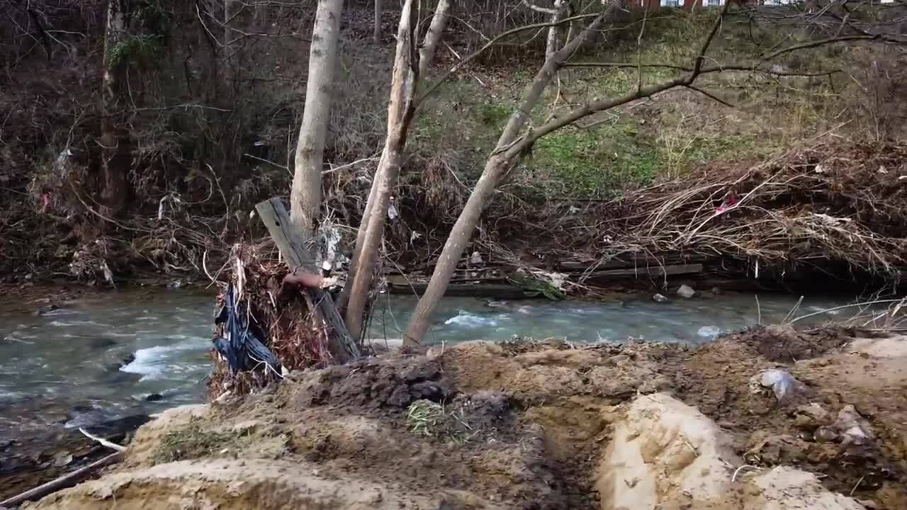
Early in the morning on January 1, the normally 25-foot-wide, shin-deep stream rose to nearly 30 feet in a matter of minutes, bringing with it heavy debris that further choked the narrow creek bed. Water rushed into yards, filled up parked cars, washed away belongings, drowned some pets, and seeped into houses and trailers.
Hayton immediately knew what she was witnessing was a flash flood. She grabbed her headlamp and waded in thigh-deep water to retrieve Luna from her pen. By the time she freed her dog, water was up to the top step of their porch, lipping the bottom of their trailer, which is propped four feet off the ground on cinder blocks. Five years ago, with a future flood in mind, they’d elevated the trailer six more inches.
“My stepdad drew a line on the breaker box of the flood line from the big flood back in 2009,” Hayton said. “That way, even if we did get a flood that bad again, we knew our trailer would be OK.”
But it wasn’t.
She and her husband, Brandon, a volunteer firefighter in nearby Pikeville, frantically packed suitcases, unsure if their trailer would be pushed off its foundation and sink like a leaky boat. Water, still rising, had started to gurgle and seep through their vents.
Using hiking poles underwater for stability, Hayton waded now through chest-deep water to the highest part of their driveway above the water line. Brandon threw the packed suitcases as far as he could, and she dragged them with a long stick to dry ground. The sun was just starting to rise.
Less than a tenth of a mile away, in the lowest part of the Bottom at a bend in the creek, Joey Smith, 26, couldn’t sleep. It had been raining most of the night, so, like Hayton, he looked out the window to check the creek’s level, and noticed a fast current of muddy water surging into his yard.
He woke his mom and dad, kids, sister Raven, her husband KJ and their kids. Five minutes later, the water was on their porch. Then it was inside their double-wide trailer. Outside, it was flush with their windowsills.
The water line in their trailer eventually reached seven inches. Smith and his family strapped life jackets on their children and splashed through shin-deep creek water to grab and pile valuables on shelves, unsure if their trailer would lift off its foundation and be swept away.
Later that morning, Raven watched from the porch as emergency rescuers attempted to wade across a bridge over Big Creek to get to their house. They turned back when the water levels reached their necks. The Smiths were marooned.
The 48-hour period of storms and torrential rains in Eastern Kentucky flooded streams, creeks, and rivers, causing millions in damage to homes, buildings and roadways, was part of a statewide spate of extreme weather. Thirty-six hours after temperatures surpassed 70 degrees on New Year’s Eve in Sidney, the town was under a winter weather advisory. The same unseasonably warm weather system that brought torrents of rain also brought hail, strong straight-line winds, and spun out tornadoes across west Kentucky. Sidney, with a population less than 900, was just one impacted community. Gov. Andy Beshear declared a state of emergency.
This string of erratic and severe weather wasn’t an anomaly, just the latest in a stretch of extreme events to hit Kentucky. In addition to floods and tornadoes, the first week of 2022 also brought with it substantial snowfall across much of the state, including 10 inches in Lexington. Less than a month earlier, on December 10, historically calamitous tornadoes ripped through western Kentucky, killing 78 people and flattening towns like Mayfield and Dawson Springs.
Almost a year earlier, last March and February, widespread flooding was recorded in 31 Kentucky counties, from Fayette to Martin, from Anderson to Boyd. Hundreds of people were displaced, including in Beattyville, Booneville and Prestonsburg, and the state tallied more than $72 million in damage. President Biden in April declared a state of emergency, triggering the release of federal funds and allowing affected residents to qualify for individual assistance and local governments, public assistance. It was the largest award for people flooded out of their homes in more than a decade, Beshear said at the time.
Pervasive hidden flood risk
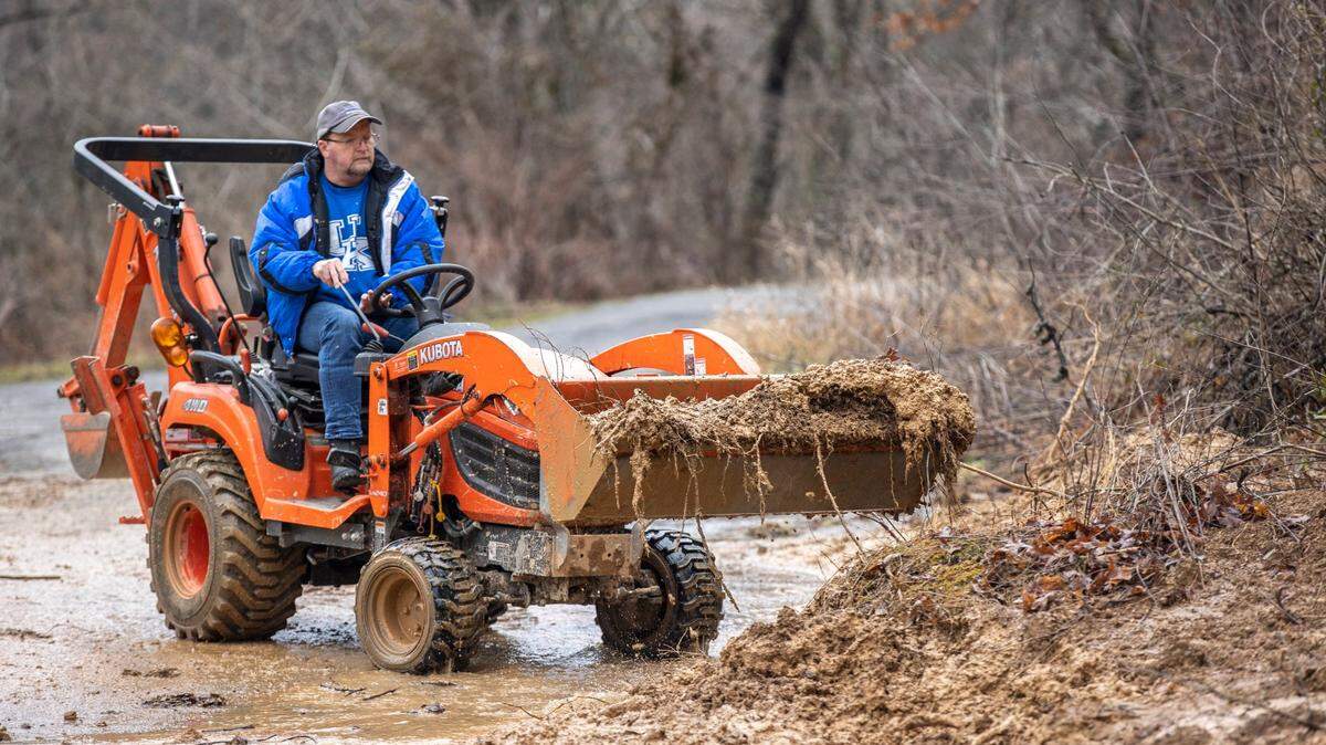
Floods and flash floods have long been a way of life in Eastern Kentucky, where communities are often planted in narrow valleys between steep ridgelines – terrain that functions like a clay bowl when it rains, filling up from the bottom and softening hillsides that increasingly slough off, creating landslides and mudslides.
But the severity and frequency of flooding is unequivocally projected to worsen in the coming years as the climate continues warming, ultimately bringing more precipitation to vulnerable, unsupported terrain. Abandoned surface mines compound the land’s susceptibility for flooding and landslides. Compacted soil and treeless, tiered topography left by strip mines acts as a slippery surface and reduces land’s ability to absorb water. Lacking root systems that act as a natural guard against erosion, these steep slopes in some cases are more likely to give way, especially after heavy rainfall.
“As we look into the future, all the models we see predict more rainstorms and more precipitation,” said Director of the Kentucky geological survey Bill Haneberg.
But there’s no comprehensive flooding protection road map for communities facing severe flood risks in Kentucky. As a result, much of the response to flooding is reactive and slapdash, with individual communities left scrambling to clean up devastation from storms, but with too few resources to preemptively plan for the next one. Residents, like those in Smith Bottom Loop, are too often left behind.
Kentucky’s mitigation approach up to this point has largely been piecemeal, likely because there is little to no statewide preemptive response to protect residents from the costliest natural disaster. In 2018, the state released a Risk Assessment and Hazard Mitigation Plan, which outlines community-level risks and superficially touches on four general resilience strategies, such as, “engineer or retrofit roads and transportation structures to withstand flooding,” and, “relocate vulnerable populations outside the flood hazard areas.”
Eastern Kentucky is among the most vulnerable land-locked terrain when it comes to flooding from rainfall. The Federal Emergency Management Agency’s maps do not adequately capture flood risk from rainfall — and in turn, who should invest in flood insurance through the National Flood Insurance Program — meaning hundreds of thousands more people may be vulnerable to flooding and not know it.
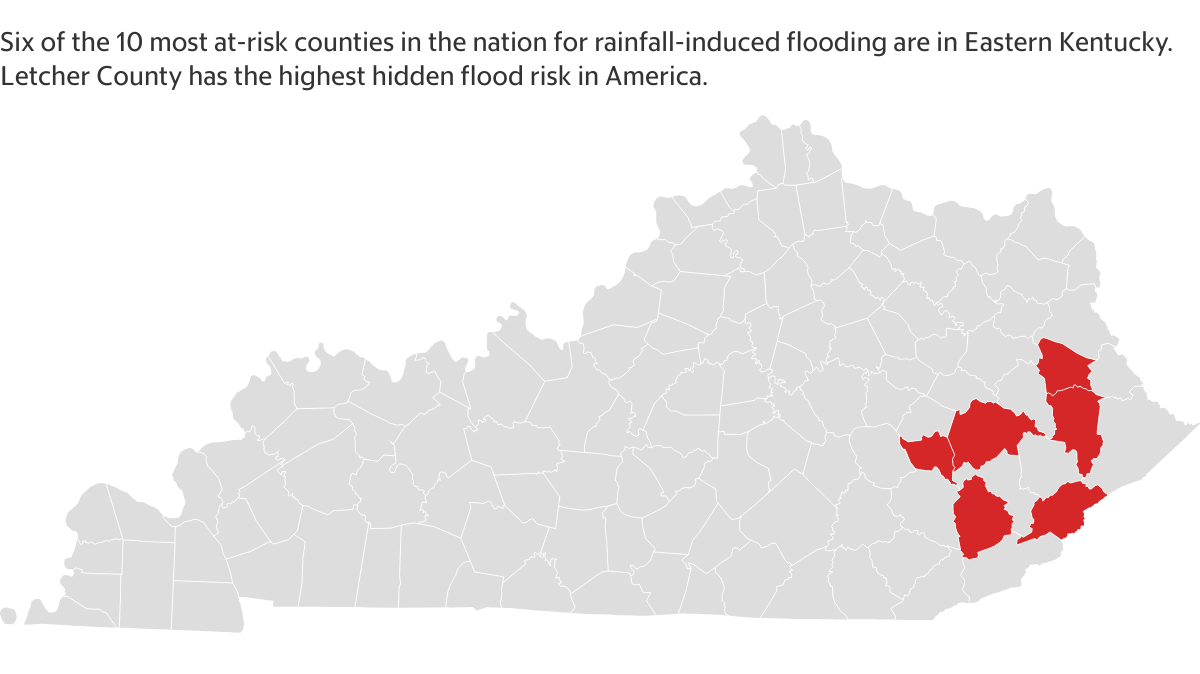
Six of the top 10 (and nine of the top 20) counties in America with the highest hidden flood risk are in Eastern Kentucky, according to data from the First Street Foundation, a nonprofit flood research and communications group that charts property-level flood risks. Hidden flood risk is the discrepancy between how much flooding FEMA claims happens versus how much flooding actually happens.
Letcher County has the highest hidden flood risk in the nation, outranking New Orleans. FEMA maps for Letcher County show 1,456 houses are at risk of flooding. First Street’s more exhaustive property-level maps show that number is significantly higher: 7,358, a 47% difference.
Hazard has the largest proportion of properties at risk (32%), and Farley in McCracken County has the greatest relative growing risk. Six percent of the town’s properties faced a substantial flooding risk in 2020; over the next 30 years, that percentage is projected to jump by 261%.
Other counties with substantial hidden flood risks include Johnson, Leslie, Breathitt, Floyd, Owsley, Magoffin, Perry and Martin. This is likely an undercount, however, as 10 Eastern Kentucky counties with high propensities for flooding, including Pike and Knott counties, have yet to digitize their parcel boundaries, preventing First Street and others from accurately gauging the extent of flood risks. But those risks are charted in other ways. According to Kentucky’s 2018 Risk Assessment, between 1974 and 2018, Pike County residents filed more flooding insurance claims than any other county in Kentucky except Jefferson County, the most populated.
Haneberg, with the Kentucky Geological Survey, is working on the newest draft of the state’s risk assessment and hazard mitigation plan, slated for completion in 2023.
“This is the first time we’re going to be explicitly addressing the likely effects of climate change on long-term hazards” such as flooding and landslides, said Haneberg. Separately, Haneberg is part of a team the Federal Emergency Management Agency has tasked to map areas in the Big Sandy Development District, which includes Pike, Magoffin, Johnson, Floyd and Martin counties that are at risk for landslides – another natural disasters projected to become more common in the future.
‘Who’s going to buy their home?’
For decades, Eastern Kentucky’s crumbling infrastructure and dwindling tax base, driven in large part by the loss of the coal industry, has failed to adapt to increasing rainfall. Families are left repeatedly incurring damages to not only their homes, but their roadways, bridges, water lines, sewers and septic systems. This undue burden placed on residents further erodes financial security in a historically low-income region.
Relatively all of Sidney is in a special flood hazard area, but no one interviewed for this story has flood insurance; in a a town where the median income level per household is close to $35,000, many families don’t even entertain forking over thousands of dollars a year in flood insurance.
Zeke Stepp, who pastors Sidney Missionary Baptist Church, a low-slung brick building across the street from Big Creek, canceled the roughly $3,700 flood insurance policy for his church last year. Through the COVID-19 pandemic, church attendance shriveled and so did his coffers.
“We couldn’t afford it. There was no way,” said Stepp, who was chaperoning a lock-in with his youth group inside the church when flood waters swelled over Big Creek’s bank. He and more than 20 kids scrambled up a nearby hillside and took shelter in a neighbor’s garage to avoid the water, which caused $15,700 in damage to the church, and another $3,000 to the double-wide trailer behind it that serves as the parsonage, where Stepp lives with his wife and kids.
Some counties, through a combination of federal and state money, are trying to fix the problem on the front end by replacing and enhancing waterway infrastructure. Floyd County, for instance, has sized up some of its drainage pipes and culverts after repeated flooding.
“We’re getting more water volume and have to prepare for that. If not, it’s just going to be a continuous cycle,” Judge Executive Robbie Williams. “Instead of patching, we need to correct and fix this stuff long-term. Why go back and replace a 36-inch culvert with a 36-inch culvert that we’ve replaced four times over the last 10 years? Obviously 36 inches isn’t going to work.”
One of the more substantial mitigation projects is 17 miles southeast of Sidney in Coal Run Village, where the U.S. Army Corps of Engineers has $119 million plans to construct flood walls and levies around the flood-prone village. Ninety-five percent of that cost is covered by the federal government, Pike County Judge Executive Ray Jones said, leaving the state and county to each front 5% (roughly $650,000).
Though it’s a sliver of the overall cost, matching anywhere close to that amount for a similar flood-proofing project isn’t feasible in smaller Eastern Kentucky counties, where low-wealth status of residents, withered economies, and limited county operating budgets mean investments in resilience studies and flooding infrastructure often don’t take priority.
In 2019, Magoffin County logged nearly $5 million in flooding damage. Magoffin County Judge Executive Matthew Wireman didn’t have time to wait for FEMA to reimburse for the damage, so he pulled from his own budget, as many county administrators do.
“I was having to expend my cash, and it took months and months to get it back (from FEMA),” Wireman said. “I’m still working on FEMA projects from a year ago, and I’m struggling. I have to do one, get reimbursed, do one, get reimbursed. It’s just a bad system.”
A year later, after another severe flood in early 2020, the Army Corps visited to assess the county’s infrastructure.
If the county wanted the corps to complete a resilience report to help county administrators key in on steps to take to to lessen the impact of future floods, “They said we would have the opportunity to apply for a grant,” Wireman said: Magoffin County could pay for half, estimated to cost up to $100,000, and the corps would match it.
“If this was in an urban area, they could afford that match,” Wireman said. “But my general fund’s about $2.5 million. To pull a hundred grand out of it to do a study and not see anything tangible from it, that’s just not a wise use of money. I’ve got so many pressing needs here in a poor, rural county, that’s just one of many.”
Wireman knows his infrastructure is weakened, and that the warming climate portends much more rainfall. “If we look at the data over the past four to seven years, we’ve had more rainfall during that time frame than we’ve had in my lifetime. The ground is saturated, and we see it on our roads, where the embankments are falling off. In more places, we have to drive steel and use railing cribbing because the ground is so saturated now.”
But his options are limited because of financial constraints; he can’t look forward to preemptively plan for the next flooding event because he’s still preoccupied with fronting money to patch problems left by past floods until FEMA reimburses for the cost.
Even though his county budget is significantly larger, Floyd County Judge Executive Williams can relate.
Flooding last March caused $3.5 million in damage, and, like Wireman, Williams had to pull money from his budget to front the cost of more immediate repairs and wait until FEMA reimbursed him.
“That tapped us,” he said. In anticipation of the next big storm, “we had to take out a line of credit.”
For people who live in floodplains, it’s becoming a Catch-22; FEMA buyouts are a good option and one that people continue to take, but that process takes years. Williams said he recently helped FEMA finalize closing on a home in his county from a flood in 2013. He’s got 200 or so more that need to be relocated. Most of the residents he sees who sign up for this process “drop out of the program before they get to completion,” he said.
“These folks who are being flooded, they don’t want to be in those floodways, but who’s going to buy their home?” he said. “What’s the home worth sitting in a flood plain? They’re at the mercy of their finances, [and] they don’t have the resources to move. So, they sit there and fight the flooding time and time again.”
That’s the case with the Smiths in Smith Bottom Loop. They know their home isn’t worth much, especially now with the significant water damage, but they also can’t readily afford to leave. Two weeks after the January 1 flood, as Pastor Zeke and KJ were replacing the mud-soaked floors with new ones that had been donated, Joey said he was torn.
“I’ve grown up here my whole life. My dad has lived here for 60 years,” he said as KJ drilled into a floor beam in one of the children’s bedrooms. “I don’t want to leave, but it’s a serious risk, [knowing] the house could be destroyed again any time it rains.”
‘You can only raise a house so high’
In a perfect world, Leranda and her husband could pool their money into building a modest flood-proof home and buy flood insurance in order to stay in Smith Bottom Loop next door to her mom and step-dad.
“I know it’s not much, it’s not a big, nice, fancy home. But it’s still home to us,” she said a few days after the January 1 flood.
Leranda’s family has been tied to this swath of low-lying land for more than 100 years. Her step-father, who’s 75, was born and raised across Big Creek a stone’s throw from where she and her husband live now. Leranda and Brandon got married in the Bottom and moved down here four years ago. Like family before them, they’d intended to stay, knowing they would always live with the reality of flooding. Hayton, who’s 35, estimates she’s lived through at least four floods. Her mom, two houses down, has seen at least eight in the last 20 years.
But the repeated financial and personal losses are becoming hard to bear. Hayton and her husband’s trailer is unlivable. The water damage tore out insulation underneath and the moisture has caused the interior walls to crack. This trailer was also only a temporary home - further down in Smith Bottom, they’d begun to build and furnish a permanent home. It, too, was flooded.
“To just sit there and watch everything that you worked for swept away time after time, it just gets so discouraging,” Hayton said from a cousin’s house in Pikeville, where she and Brandon are staying temporarily until they can find an apartment.
“My poor mom sent me a Facebook message this morning at 2 a.m. begging us not to move because they would miss us if we wasn’t living next to them, and said they’ll offer to help us in any way they can,” Hayton said. “I’m devastated. It’s so hard to leave, but it’s so hard also to put something new there, knowing it could be flooded and taken away at any time.”
Hayton has seen her mom and step-dad rebuild time and time again — one year they relocated their house farther away from the creek and elevated it. Other years their basement floods, or their yard and garden are repeatedly washed out, and they have to replant everything in the spring. It’s hard to imagine investing in a place that’s guaranteed to betray you, she said.
“Everything that they’ve worked for all year round: their garden, their flower bed. They’re retired, that’s their projects. And every couple of years it gets completely ruined,” she said. “I just don’t want to have to do that my whole life. We’ve very been fortunate so far that nobody’s got hurt, all of our pets have been safe. But you can only get that lucky for so long. And you can only raise a house so high.”
This story was originally published January 23, 2022 at 5:00 AM.