Landslides pose greater risk in Eastern Kentucky as climate change brings more rain
READ MORE
Waiting for the creeks to rise
As flooding becomes more frequent, vulnerable Eastern Kentucky communities wrestle with how much damage they can take
Expand All
Flooding is Kentucky’s costliest and most frequent natural disaster. But one expert says landslides are on deck to pose an even greater risk in some parts of Eastern Kentucky.
As the climate continues warming, dramatically increasing precipitation levels across the country and in virtually all of Kentucky over the next years and decades, the same rainstorms that are likely to flood creeks, streams and rivers will also increasingly soften steep, sloped land and cause landslides and mudslides, said State Geologist Bill Haneberg.
“We’re reaping the effects of a warming Gulf of Mexico in terms of getting more water into the atmosphere,” said Haneberg, who’s also director of the Kentucky Geological Survey and a research professor at the University of Kentucky.
“All models we see predict more rainstorms. We can analyze potential landslides sort of like a physics class problem: if you have a block of soil resting at a slope, what are the conditions it takes to move it?”
Though flooding is somewhat predictable in Kentucky, landslides aren’t always. That’s why Haneberg and a team of other UK researchers are working with the Federal Emergency Management Agency to draft landslide susceptibility maps for the Big Sandy Area Development District in Eastern Kentucky, which includes Floyd, Magoffin, Johnson, Martin and Pike counties.
Using LiDAR technology — essentially airborne laser scanning — Haneberg and his team are mapping the topography of these counties to get digital elevation models to better gauge landslide-prone areas.
By keying in on these areas, it’ll give counties a better idea of which land is particularly susceptible to a landslide or mudslide so local governments can take steps to prepare for them. Early results from Haneberg’s study, which he said are “highly preliminary,” show there “may be considerable decreases in hill-slope stability in areas with thin soils, and if soils are wet from previous rainstorms.”
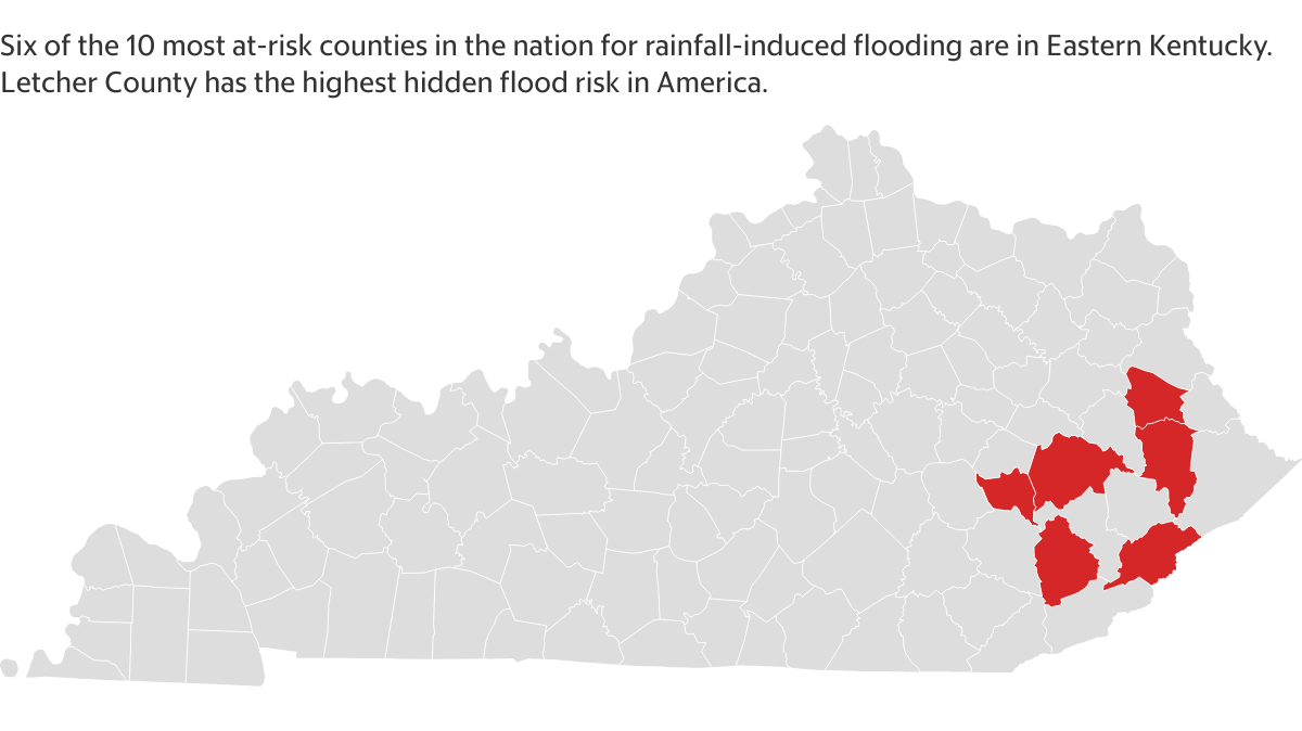
It’s already generally known that Kentucky’s steep, hilly terrain is prone to landslides, but Haneberg’s map will allow state and local governments to pinpoint exact areas likely to give way. According to FEMA’s National Risk Index map, Perry, Knott, Floyd and Martin counties have a “very high” risk for landslides.
The index maps determine risk by measuring county social vulnerability and community resilience. Martin County, for instance, has among the lowest rankings in the nation for “ability to prepare for anticipated natural hazards, adapt to changing conditions, and withstand and recover rapidly from disruptions,” according to FEMA.
Though the FEMA landslide mapping project won’t be complete until the spring, Haneberg’s “LiDar-based landslide inventory” has already digitized 1,054 areas across Magoffin County prone to landslides.
Surface mined land presents another threat for landslides. Compacted soil and treeless, tiered topography left by strip mines acts as a slippery surface and reduces land’s ability to absorb water. The lack of root systems that would normally help hold this land in place increases the likelihood for it to give way, especially when hillsides are saturated with heavy rainfall.
Haneberg’s ongoing physics-based research into certain terrain’s landslide susceptibility, coupled with the new FEMA inventory map, will also “allow us to include projected water pressure changes due to increased rainfall, as the climate becomes wetter,” he said. “The first step is to understand how the models compare for current conditions, and then use them to predict future conditions.”
‘There’s nothing he can do’
A severe string of storms that moved through Kentucky on New Year’s Eve that spun out tornadoes in parts of western Kentucky and torrential rain that led to devastating flooding in Eastern Kentucky also caused landslides. Gov. Andy Beshear declared a state of emergency.
Unlike flooding, there is no comparable insurance program for people who sustain damage from landslides. That means many people who experience landslides and mudslides are often left to recuperate those losses on their own. Floyd County Judge Executive Robbie Williams in his office last week showed a picture a resident had texted him of a landslide that had washed away his backyard and run into his house.
“”This has come off a mountain. That’s his home,” Williams said. “There’s no help for him. There’s nothing he can do.”
Enacting harsher zoning preventing development and certain erosion stabilizing measures can be taken to avoid the increased risk posed by landslides. And Williams knows this. In most rural counties, outside of city limits, there is no zoning.
“We need to strengthen our zoning laws [dictating] where folks can and can’t build,” he said.